 Mijn Studiezaal (inloggen)
 145 foto's
sorteren op:
203 Topografisch-Historische Atlas Doorn
Catalogus
1. Foto's
5 Grote luchtfoto’s, 1980-1999

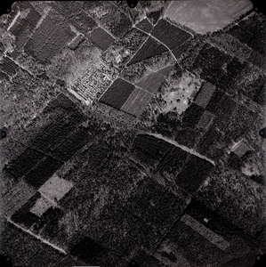
Luchtfoto gemeente Doorn: Heuvelrug-zijde met oa. Maarnse Grindweg (strook 007, foto 0146)
Catalogusnummer:
11366
Datering:
29-03-1991
Soort:
Foto
Gebied:
Doorn
Auteur:
KLM Aerocarto
Inventarisnummer:
5
Bijzonderheden:
Schaal 1:6000
laatste wijziging 23-01-2020
1 gedigitaliseerd
203 Topografisch-Historische Atlas Doorn
Catalogus
1. Foto's
5 Grote luchtfoto’s, 1980-1999
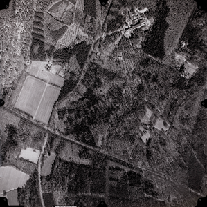
Luchtfoto gemeente Doorn: Heuvelrug-zijde met oa. Rijksstraatweg en De Hoogstraat (strook 008, foto 0161)
Catalogusnummer:
11367
Datering:
29-03-1991
Soort:
Foto
Gebied:
Doorn
Auteur:
KLM Aerocarto
Inventarisnummer:
5
Bijzonderheden:
Schaal 1:6000
laatste wijziging 23-01-2020
1 gedigitaliseerd
203 Topografisch-Historische Atlas Doorn
Catalogus
1. Foto's
5 Grote luchtfoto’s, 1980-1999
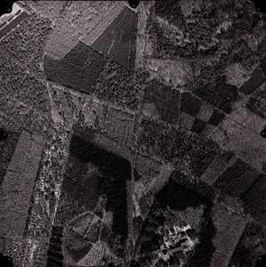
Luchtfoto gemeente Doorn: Heuvelrug-zijde met oa. De Bonte Vlucht en De Hoogstraat (strook 008, foto 0163)
Catalogusnummer:
11368
Datering:
29-03-1991
Soort:
Foto
Gebied:
Doorn
Auteur:
KLM Aerocarto
Inventarisnummer:
5
Bijzonderheden:
Schaal 1:6000
laatste wijziging 23-01-2020
1 gedigitaliseerd
203 Topografisch-Historische Atlas Doorn
Catalogus
1. Foto's
5 Grote luchtfoto’s, 1980-1999
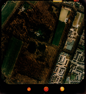
Luchtfoto (kleur) gemeente Doorn: Langbroek-zijde met skeelerbaan, hockeybanen, Rijksstraatweg (nr. 5847). 1: ca. 1000
Catalogusnummer:
11369
Datering:
24-03-1991
Soort:
Foto
Gebied:
Doorn
Auteur:
KLM Aerocarto
Inventarisnummer:
5
Bijzonderheden:
Schaal 1:ca. 1000, voor lokatie zie verzamelblad onder barcode 011426
laatste wijziging 23-01-2020
1 gedigitaliseerd